Innovative Geospatial-Information Technologies To Support Warfighters Needs
With the most recent and upcoming high resolution radar and optical spatial sensors and missions in Europe, the future for commercial GEO-Information Services to meet warfighters´ needs in operations is very promising. The world in 3D, a void-free and reliable elevation model with a relative vertical accuracy of better than 2 m will be available soon. Very high resolution commercial geospatial products and services meeting requirements across the ISR-value chain will become reality.
Geospatial-information is vital to tackle regional and global security challenges
Space-based Earth observation, providing reconnaissance data of any place in the world, at any time and with virtually no territorial restrictions is of tactical and strategic relevance for national security and defence. A variety of space based sensors, both military and commercial, provide Geospatial information data vital for decision makers to face the global security challenges. Military and security operations such as border control in isolated areas depict a complex environment in which strategic reconnaissance data as well as sufficient data for the joint operations targeting cycle (find, fix, track, target, engage and assess) are required. The data will be provided by a mix of sensors and platforms at the strategic, operational and tactical level in order to satisfy users´ needs of information meeting the required accuracy, resolution and timeliness. In this environment and in addition to purely military owned capabilities, commercial GEO-information services become of increasing interest for intelligence and monitoring tasks. A few select countries such as Turkey can realistic aspire to, and are indeed developing their own spaceborne Earth Observation capabilities. Even, or especially, such sophisticated countries see the value of additional sources of data, either to bridge contract-to-launch tactical needs or to permanently augment their sovereign assets. Capabilities of commercial Earth Observation spacecraft and satellite constellations are continuously improving and, nowadays, satisfy global reconnaissance needs. This includes short development cycles and innovative financing models.
Astrium GmbH’s SAR capability and cooperation opportunities
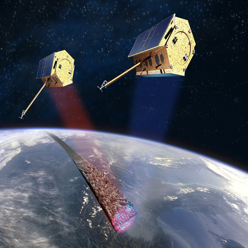
Over the last decades Germany has established a globally unique SAR technology line, supported by the national high-tech strategy, and developed by Astrium GmbH in Friedrichshafen in close cooperation with the German Aerospace Center (DLR). The most recent member of this SAR family is the TanDEM-X mission, which consists of the two satellites TerraSAR-X and TanDEM-X, both developed in Public-Private-Partnerships (PPP) between DLR and Astrium GmbH (artist view see figure 1). The TerraSAR-X satellite was launched in June 2007 and the commercial services, conducted by Infoterra GmbH (the German arm of Astrium's GEO-Information Services Division), started in January 2008. Image data distribution is in compliance with Germany’s Satellite Data Security Law (the so-called "SatDSiG"). The X-band SAR sensor provides a spatial resolution of 1 metre and even better. The pixel location accuracy is within the pixel size (for clarity to the uninitiated: this is an outstanding technological achievement!). TerraSAR-X offers extremely reliable, weather&daylight-independent, and precise image acquisitions, as well as elevation measurements, change detection and surface motion monitoring capabilities. In 2009, the U.S. National Geospatial-Intelligence Agency (NGA) confirmed the outstanding geo-location accuracy of the data. Direct reception services can be implemented for customers around the globe. Currently ground stations in Germany, Japan and in the U.S. including the mobile Eagle Vision System receive TerraSAR-X data.
An almost identical spacecraft to TerraSAR-X has been launched as TanDEM-X (TerraSAR-X add-on for Digital Elevation Measurement) in June 2010, now flying in a unique satellite formation with TerraSAR-X at distances of only a few hundred meters, allowing for stereoscopic views to be taken round-the-clock. The formation will collect the so-called interferometric data-pairs over the global land mass to establish a globally homogeneous Digital Elevation Model (DEM). During the three years of DEM data collection (now only two remaining), the formation will nevertheless remain available for regular radar imaging, thanks to an optimized acquisition plan. Key features of this DEM are its relative vertical accuracy of better than 2m within a horizontal raster of approximately 12x12 m2 covering the entire land surface of the Earth, i.e. 150 Million Km2. Thus, the successful start of the close formation flight in late 2010 marked the beginning of a new era of global digital elevation data provision.
Unclassified Satellite Data for Reconaissance Observations
SAR (Synthetic Aperture Radar) is one of the important capabilities allowing Earth Observation in all weather conditions, day and night. In addition to the pure SAR imagery, SAR data contains phase information that can be used to detect subtle changes below the spatial resolution of the SAR sensor (called "Coherence Change Detection" - CCD). Further, changes within the range of the spatial resolution can be indicated by using the intensity (amplitude) of the SAR data (called "Amplitude Change Detection" - ACD). The evaluation of CCD and ACD data enables a change analysis, i.e. the precise identification and accurate current change information about a remote area of interest. Astrium GEO-Information Services offers such an analysis capability with its web-based change detection platform "SPOTmonitoring", where the user can take advantage of information derived from multi-source and multi-resolution satellite imagery (example see figure 02 a/b). Today, approximately 60 sites around the globe are regularly being monitored, for operational use of defence and security agencies, large corporations and international organizations. Additionally, the GEO-information experts offer individual, site-specific automated change detection based on radar imagery.
Precise elevation data is the initial foundation of any accurate geospatial product, particularly when the integration of multi-source imagery and data is performed based upon it. Topographic mapping, communications network planning, hydrologic modeling, air traffic security and, last but not least, the reliable orthorectification of high-resolution satellite imagery are only examples of the wide range of applications that benefit from precise, reliable elevation data. The addition of elevation models to SAR and optical imagery allows also a deeper insight into the actual terrain conditions of an area of interest, often supporting a sound interpretation of items that may be unclear when viewed in pure 2D imagery (example see figure 03).
In addition to monitoring the occurrences apparent on the Earth's surface, innovative methodologies also enable the detection of sub-surface activities. TerraSAR-X radar satellite data is ideally suitable to detect movement of the Earth's surface with millimetric precision. These precise monitoring applications can be utilised in construction site monitoring of e.g. tunnels, subways or bunkers, for supervising effects of sub-surface mining or underground gas storage. However, such slight disturbances of the surface can also give an indication of an ongoing underground expansion of existing facilities or the excavations of tunnels and caves. The uniquely precise geo-location accuracy of TerraSAR-X data and the derived information assures that the extracted details can easily be integrated into the monitoring systems used by the respective user organizations today. Further, such radar-based evaluations are significantly enhanced when they are backed by additional satellite data and/or information such as DEMs.
Although both satellites have a design lifetime of about 5.5 years each, the seamless performance of TerraSAR-X for more than four years now indicate that both systems are likely to remain fully operational for the total availability of their consumables, which comprises more than 7 years for each of these two extraordinary birds.
NATO, including its two largest armies (the US and Turkey) may also benefit from these innovative GEO information services provided by commercial constellations and missions.